Back to Dashboard

What extreme heat means for Randwick

Maroubra Beach during summer months

Maroubra Beach during the summer months

Extreme heat can be very dangerous. It is a serious health risk for our community wellbeing, particularly when hot conditions last for several days and become a heatwave.

In Randwick, coastal breezes can reduce peak daytime temperatures, but humidity and warm nights often make it hard to cool down. As climate change drives more frequent and intense heat across Greater Sydney, managing heat exposure is an increasing challenge for everyone.

How extreme heat affects our community

In Randwick, extreme heat affects daily life, health and essential services. Hot nights increase health risks, particularly for people without access to air-conditioning or well-ventilated housing. These impacts are often made worse by high numbers of buildings, roads and other hard surfaces which absorb and retain heat, reducing nighttime cooling.

Across Australia, heatwaves are the deadliest weather-related hazard, causing more deaths than bushfires, floods and storms combined. Across Greater Sydney, we are experiencing longer and more intense heatwaves than ever before, increasing temperatures in our community.

Key impacts

  • Increased risk of heat stress, dehydration and other heat-related illness
  • Increased pressure on hospitals, aged care and emergency services
  • Reduced safety and productivity for outdoor workers
  • Greater energy demand for cooling, increasing household costs
  • Failure of roads, power, buildings and transport

Those most at risk

  • Older people and isolated residents
  • People with chronic illness or disability
  • Babies and young children
  • Low-income households without home cooling
  • Outdoor workers
  • People experiencing homelessness
  • Pregnant women
  • Individuals using certain medications that increase heat risk
Heat Vulnerability Map 2022

Coogee Beach during summer months

Where extreme heat has the biggest impact in Randwick

Heat exposure is not evenly distributed across the LGA. Some areas are hotter than others, particularly neighbourhoods with lots of buildings, higher housing density, less vegetation, and certain building types.

Higher risk locations include:

  • High-density areas with limited airflow and ventilation.
  • Areas with low tree canopy and limited shaded public space.
  • Locations with large amounts of hard surfaces, such as concrete, asphalt and paved areas, which absorb and hold heat (e.g. town centres, major roads or interchanges, shopping and education precincts like UNSW).
  • Older houses and apartment buildings that hold heat, particularly overnight.
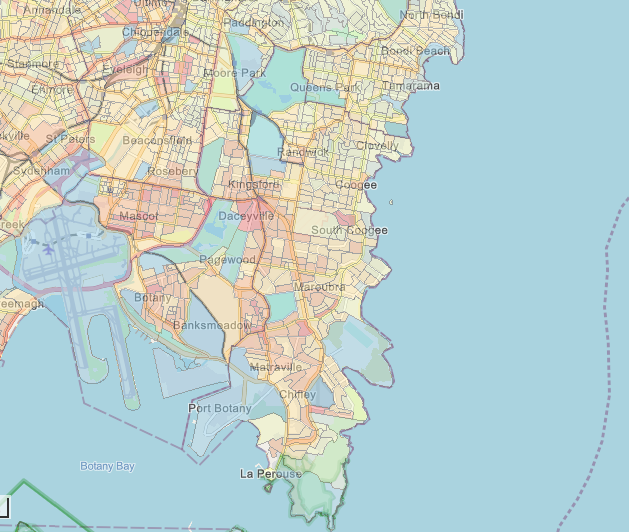
Heat Vulnerability Map 2022

Heat Vulnerability Map 2022, NSW Government

Recent extreme heat examples for Sydney

  • Summer 2025/2026 – Sydney CBD experienced two separate days of 42.2°C.
  • January 2021 - Sydney (Observatory Hill) recorded consecutive days over 30 °C from 22 to 26 January. This was the ninth time this has occurred since records began in 1859.
  • January 2020 - Penrith in Western Sydney was ranked the hottest place on earth recording 48.9°C.
  • Summer 2016/2017 – warmest summer on record for Sydney with a mean temperature 2.8°C above average.

What you can do

Reduce heat exposure

Stay indoors during the hottest part of the day (typically 11am–5pm). If your home becomes too hot or you don't have air conditioning, seek relief at a cool refuge nearby.

Protect yourself and others

  • Drink water regularly, even if you don’t feel thirsty. If you’re out and about, use this map of bubblers in the LGA.
  • Check on neighbours, particularly older people and those living alone.
  • Watch for signs of heat-related illness, especially in babies, children, older people, and those with chronic conditions.
  • Take extra care when working or exercising outdoors, and reschedule strenuous activity where possible.
  • Plan ahead for pets during hot weather, ensuring they have access to shade and fresh water, are not exercised during peak heat, and are never left in parked cars.

What severe storms mean for Randwick

SES clearing fallen trees, 2025

SES clearing fallen trees and branches on Little Bay Rd, 2025 — Source: Randwick News

Severe storms in Randwick can bring heavy rainfall, strong or damaging winds, hail, lightning and dangerous coastal conditions. Along the coast, storms can develop quickly and cause widespread disruption over a short period of time or, in some cases, last for several days.

One of the most impactful storm events that affect Randwick are East Coast Lows. These are powerful low‑pressure weather systems that form off the NSW coast and can bring extended periods of rain, damaging winds and large ocean swells. Climate change is expected to increase how often and how severe storm events are. Whilst East Coast Lows are projected to occur less often, when they do occur, they are expected to be more intense. Combined with Randwick’s coastal location, severe storms are a risk to public safety, transport and essential services.

Why severe storms occur in Randwick

  • Warm ocean temperatures that fuel intense storm systems.
  • East Coast Lows that can form after cold fronts move from Victoria into the Tasman Sea.
  • Thunderstorms, which are more common during warmer months.

How storms affect our community

Severe storms can damage homes, buildings and infrastructure, disrupting transport, energy supply and daily life for residents and businesses. Strong winds and lightning increase the risk of trees and branches falling, which can damage buildings and cause power outages that affect essential services. Hailstorms can damage roofs, vehicles and other property, while heavy rain can overwhelm stormwater systems, leading to localised flash flooding in streets, parks and low‑lying areas.

Severe storm events often cause dangerous surf conditions, coastal erosion and beach closures. For more detail, see Coastal Hazards.

Key impacts

  • Fallen trees and branches causing damage and power outages
  • Key infrastructure failure — transport or energy supply
  • Beach erosion, unsafe surf conditions and beach closures
  • Disruption to services, schools and local businesses
  • Localised flash flooding of streets, properties and public spaces

Those most at risk

  • People with disability or limited mobility
  • Residents in low-lying or flood-prone areas
  • Outdoor workers and emergency responders
  • People living in poor quality housing
  • People dependent on electrically powered medical equipment
  • People who rely on refrigerated medication
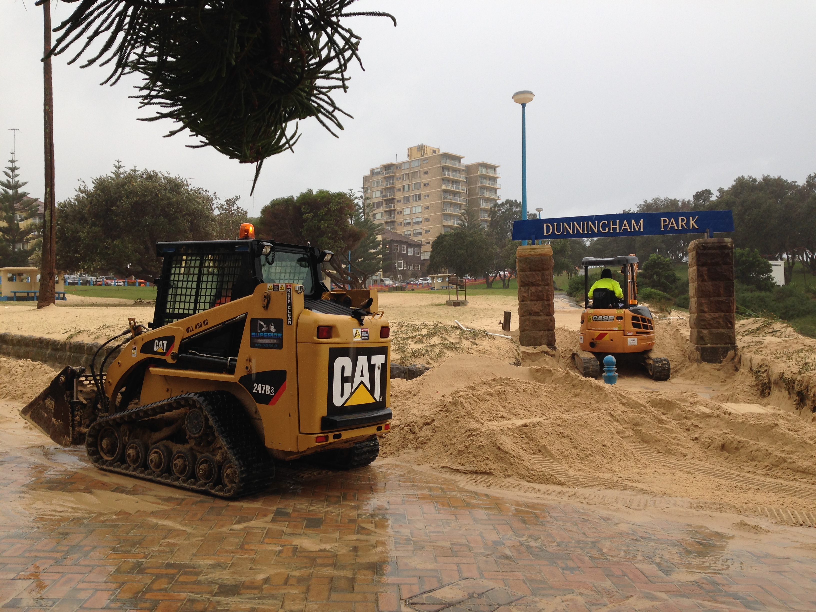
Storm clean up March 2022

Storm clean up, March 2022

How storms can cause risk to you

Severe storms will affect all of our community, however some areas have an increased risk of injury and should be avoided where possible:

  • Streets and parks with lots of trees, where strong winds increase the risk of fallen branches.
  • Major roads and intersections affected by fallen debris, power outage or flooding.
  • Low lying areas in the LGA prone to flash flooding during intense rainfall events such as Coogee Kensington, Kingsford, & Maroubra
  • Coastal areas, where storms can generate dangerous surf, erosion and access restrictions
Storm clean up March 2022

2016 East Coast Low damage at Coogee Beach

Recent storm examples in Randwick

  • July 2025 – Rainfalls of up to 99mm and winds up to 55km/h swept through Sydney’s eastern suburbs over for 24hrs, causing flooding and bringing down large trees and branches on major roads and streets.
  • March 2022 - an East Coast Low caused 58mm of rain to fall in Randwick and 67mm in Little Bay within 24 hours, triggering flash flooding and potholes. Strong winds brought down trees across multiple suburbs, while high tides eroded beaches and coastal infrastructure.
  • June 2016 – A significant East Coast Low caused widespread impacts across Randwick, including damaging winds, coastal erosion, power outages and more than 170 calls for assistance to Randwick SES.
  • April 1999 – The 1999 Sydney Hailstorm is still considered Sydney’s most expensive natural disaster. Lasting over 5 hours, the storm created hailstones up to nine centimetres in diameter that damaged 24,000 homes, 70,000 vehicles, 60 schools and 23 aircraft within suburbs in the Randwick LGA.

What you can do

Prepare before storms

  • Secure loose outdoor items such as furniture and bins.
  • Park vehicles away from trees and powerlines.
  • Ensure drains and gutters around your home are clear.
  • Stay informed by monitoring weather warnings through the Bureau of Meteorology app or SES alerts.
  • Prepare for power outages by having torches, food and alternative cooling for essential medications that require refrigeration if necessary.

During severe weather

  • Avoid unnecessary travel during heavy rain or strong winds.
  • Stay out of parks or tree-dense areas to avoid limb drop.
  • Never walk or drive through floodwaters.
  • Stay away from coastal edges, rock platforms and flooded areas.
  • Follow advice from emergency services and local authorities.

If you need help during an emergency

  • For life-threatening emergencies — call 000.
  • For storm, flood or fallen tree assistance — contact the NSW State Emergency Service (SES) on 132 500.
  • Report power outages to your electricity provider.
  • Bureau of Meteorology — East Coast Lows and Thunderstorms.
  • Report power outages to your electricity provider.

What coastal hazards mean for Randwick

Tar balls on Coogee Beach

Mcivers Baths in Coogee during huge swell as an east coast low tracks the NSW east coast: ABC News

Coastal hazards refer to the impacts on beaches, dunes, rock platforms and coastal infrastructure caused by large waves, high tides and storm events. These hazards can damage public facilities and spaces, reduce beach access, and create serious safety risks for people using the coast.

Randwick’s coastline is a much loved part of the community, while also being naturally exposed to changing ocean conditions. Its east facing coastline makes it more exposed to large swells from the Tasman Sea. Coastal hazards are expected to happen more often and be more severe as sea levels rise and storms become more intense due to climate change, placing increased pressure on beaches and coastal infrastructure.

Why coastal hazards occur in Randwick

  • Exposure to large ocean swells from the east.
  • East Coast Lows and other severe storm systems.
  • King tides combined with large waves and storm surge.
  • Cyclones and other large weather systems impacting Queensland can generate large swells that travel down the East Coast.
  • Naturally narrow beaches along most of the Randwick coastline.

How coastal hazards affect our community

Coastal hazards affect safety, access and everyday use of Randwick’s beaches and headlands. Severe weather and tides can force temporary beach closures, restrict coastal access and damage essential infrastructure. They can also create dangerous conditions for swimmers, walkers and rock fishers.

Storm events can cause rapid beach erosion, shift sand and damage paths, stairs and seawalls. In some locations, sand movement can block drainage systems, leading to local flooding near the coast. Rock platforms and cliffs can become unstable during and after storms, increasing the risk of slips, falls and rockfalls. The Randwick City coastline is the most dangerous rock fishing area in Australia. In recent years there have been 24 recorded rock fishing fatalities in the area.

Key impacts

  • Beach erosion reducing usable beach width at Coogee, Maroubra and Clovelly
  • Damage to access paths, stairs, seawalls and other coastal infrastructure
  • Sand movement blocking stormwater drains, causing localised flooding (e.g. Dolphin Street, Coogee)
  • Increased risk on rock platforms and near cliff edges
  • Temporary loss of beach access, recreation and tourism

Those most at risk

  • Swimmers and surfers during hazardous surf conditions
  • Rock fishers and people on exposed rock platforms
  • Walkers and cyclists using coastal paths and headlands
  • Beach users during storms, king tides or large swells
  • Nearby residents and businesses affected by flooding
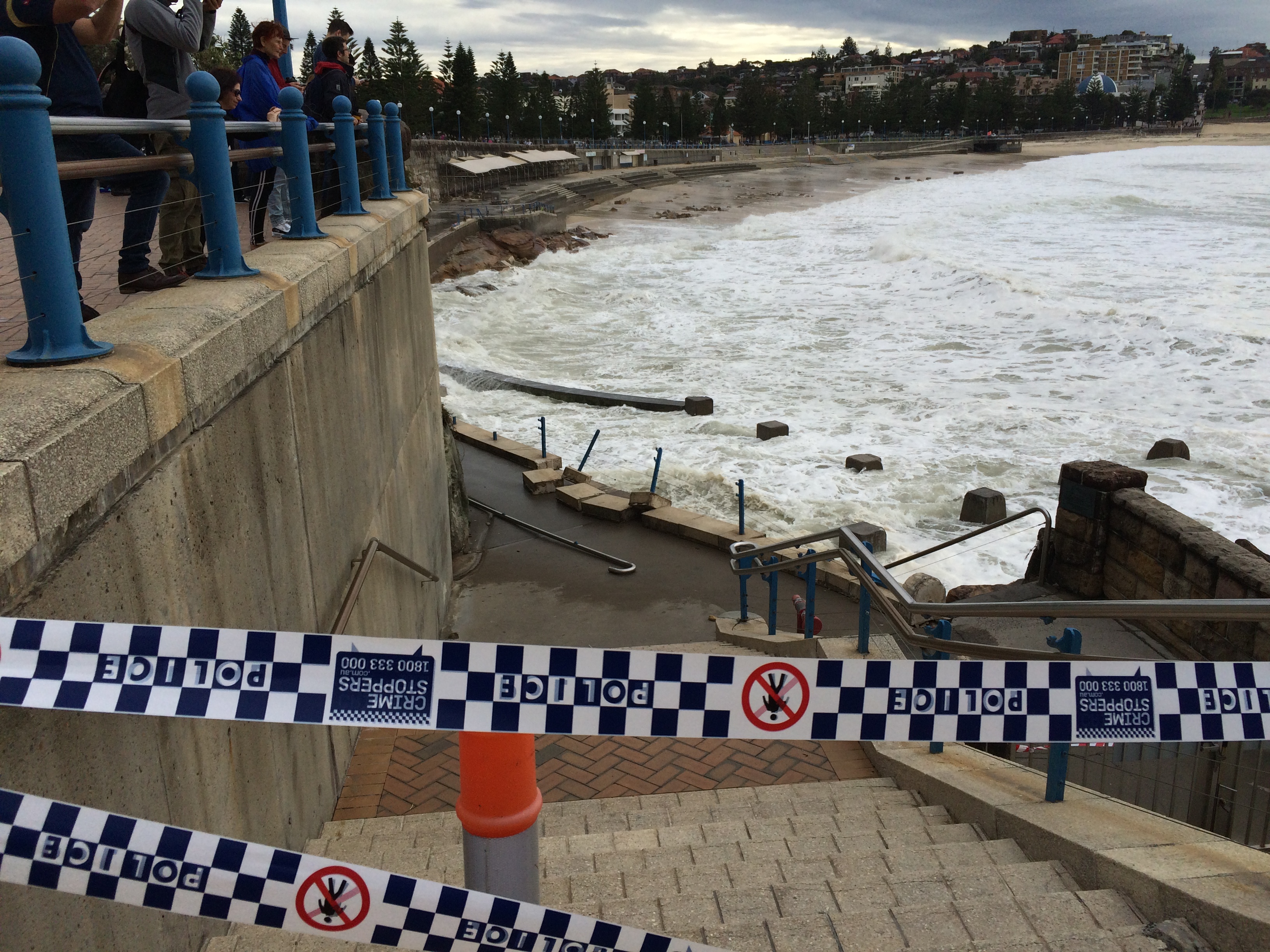
Storm Damage Coogee Beach 2015

Storm Damage Coogee Beach 2015 — Source: Randwick News

Where coastal hazards have the biggest impact in Randwick

Coastal hazards affect different parts of the coastline in different ways, depending on how exposure an area is, the shape of the land and how the area is used. In Randwick, higher‑risk coastal areas include:

  • Open and semi exposed beaches, such as Maroubra, Coogee and Clovelly, where high tide and changing swell conditions can create unsafe surf, restrict swimming areas and occasionally lead to temporary beach closures.
  • Rock platforms and headlands, such as Maroubra Headland, Malabar Headland, La Perouse and Bare Island, where wave exposure creates increased drowning risks for rock fishers and where cliffs and rock faces may become unsafe over time affecting access and public safety.
  • Sand movement blocking stormwater drains, causing localised flooding (e.g. Dolphin Street, Coogee).
Coastal hazards 3 - Coogee Beach Storms 2016

2016 East Coast Low damage at Coogee Beach

Recent coastal hazard examples in Randwick and Sydney

  • March 2026 – One of the largest swells in recent years damaged foreshore infrastructure across Randwick’s coastline, including Coogee, Clovelly and Maroubra, requiring safety inspections and repairs.
  • February 2025 – Hazardous surf and king tides caused widespread beach closures across Randwick, with lifeguards warning of unsafe swimming, rock fishing and coastal conditions at beaches including Coogee, Maroubra and Clovelly.
  • October 2024 – black balls consisting of matter from sewerage systems found along multiple beaches in Randwick including Gordon’s Bay, Coogee, Little Bay, Malabar, and La Perouse beaches.
  • August 2020 – Rockfall occurred in Maroubra causing a 25-tonne rock to fall into Mahon Pool requiring removal.
  • June 2016 – Severe storms with high winds caused a 6m high king tide that demolished the eastern wall of the Surf Life Saving Club requiring extensive repair works.

What you can do

To keep yourself and others safe

  • Check beach conditions, warning signs and lifeguard advice before entering the water.
  • Stay out of the water and away from rock platforms when surf is unsafe.
  • Keep a safe distance from cliffs, coastal edges and dunes, especially after storms or rough seas.
  • If rock fishing, be aware of changing ocean conditions, wear appropriate safety gear and avoid fishing from exposed platforms.

What flooding means for Randwick

May 2009 Flood Dolphin Street

May 2009 Flood — Dolphin Street, Coogee — Source: Coogee Bay Flood Study

Flooding in Randwick is mostly caused by heavy rain falling in a short period of time. When rain falls faster than it can drain away, water can flow over roads, paths and open spaces, causing flash flooding. In built up areas, many roads, roofs and paved surfaces stop water from soaking into the ground. This means stormwater runs quickly into drains, which can fill up and overflow, leading to local flooding during storms. Flooding can happen very quickly, sometimes within minutes of intense rainfall. During larger storm events, high tides and large waves along the coast can make flooding worse by reducing how well stormwater drains away. This increases the chance of water pooling in low lying areas. Climate change is expected to bring more frequent and heavier rainfall along the east coast of NSW. This means flooding is likely to remain an ongoing risk for Randwick.

Why flooding occurs in Randwick

  • Intense, short‑duration rainfall events causing flash flooding.
  • Drainage infrastructure reaching capacity during storms.
  • Large areas of hard surfaces (roads, roofs, pavements) that increase runoff.
  • Blocked drains, pits and gutters.
  • Coastal conditions during severe storms and high tides.

The types of flooding in Randwick

There are many different types of flooding however not all of them occur within the Randwick LGA.

Flooding type What it is Where this has occurred in Randwick
Coastal flood (storm surge) Flooding caused by very high sea levels and large waves that overtop seawalls, roads or other coastal structures during storms. Coastal suburbs — in particular Clovelly & Maroubra
Flash flooding Sudden flooding that happens when heavy rain falls in a short period of time and water cannot drain away fast enough. All suburbs — in particular Coogee, Kensington, Kingsford & Maroubra
Overland flooding Flooding caused by rainwater flowing over roads, footpaths and open spaces when stormwater drains become overwhelmed. All suburbs — in particular Kensington, Kingsford, Matraville & Maroubra

How flooding affects our community

Flooding can disrupt transport, damage homes and cars, and create safety risks for people moving through affected areas. Because flooding can happen quickly and in specific locations, impacts may occur with little warning during severe storms.

Key impacts

  • Road closures and transport delays
  • Damage to vehicles in low-lying streets and car parks
  • Water entering homes, basements and underground car parks
  • Temporary access blocked for residents, businesses and services
  • Damage to roads such as potholes

Those most at risk

  • People with disability or limited mobility
  • Residents in low-lying or flood-prone areas
  • Outdoor workers and emergency responders
  • People living in poor quality housing
Anzac Parade Kingsford 2025

Anzac Parade, Kingsford, 2025

Recent flooding examples in Randwick and Sydney

  • September 2025 – A heavy rainfall event in Sydney’s east caused flash flooding in several parts of Randwick, including Kingsford where the light rail became stranded in flood waters along Anzac Parade.
  • February 2022 - Flash flooding caused the lakes within Centennial Park to overflow affecting nearby roads and residential areas. A disaster declaration was made due to severe weather and flooding.
  • March 2020 - Sydney experienced strong winds and the heaviest rainfall in 30 years, leading to flash flooding, transport disruptions and widespread power outages. A disaster declaration was issued for several Council areas, including Randwick.
  • January & May 2009 – Intense rainfall events recorded 74 mm and 77 mm of rain within 90 minutes, causing flooding in the Coogee Bay area. In some locations, floodwater reached depths of up to three metres.
Anzac Parade Kingsford 2025

12 October 1959 Photo from Chapman Avenue looking east towards intersection of Fenton Avenue

What you can do

Reduce your risk

  • Never walk or drive through floodwater
  • Move vehicles away from known low-lying or flood-prone streets
  • Avoid underground car parks during intense rainfall

If you need help during an emergency

  • For life-threatening emergencies — call 000
  • For storm, flood or tree assistance — SES 132 500
  • Report power outages to your electricity provider
  • Report blocked drains to Randwick City Council